Winter Harbor Water Quality Summary
Winter Harbor has been given a special focus of assessment as it is the only part of Wolfeboro Waters that has been the subject of a NHDES Cyanobacteria Advisory, other than Mirror Lake. On August 30, 2018, a cyanobloom was observed and NHDES issued a Cyanobacteria Advisory urging people to avoid contact with the water at the Wolfeboro (southern) end of Winter Harbor. The public Carry Beach is at that end of Winter Harbor.
Prior to that cyanobloom, the Lake Winnipesaukee Association had received a grant from NHDES to conduct a watershed assessment and management plan for Lake Winnipesaukee in Tuftonboro. The northern part of Winter Harbor is in Tuftonboro. So, some assessment and management recommendations were contemplated for Winter Harbor. In March 2019, voters in Wolfeboro approved a warrant article that included funding for the watershed assessment to cover the whole of Winter Harbor fully. That watershed plan is currently underway with its completion planned for Summer 2020. The Assessment Subcommittee of Wolfeboro Waters has been helping to provide requested data and information to assist the development of the watershed plan.
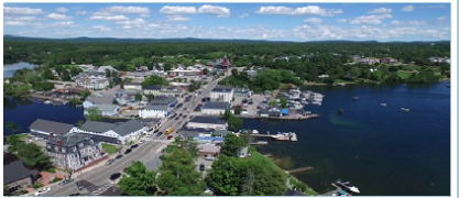
Background: Winter Harbor is a Y-shaped bay with a single outlet to the center of the lake (The Broads). The southern arm of the harbor (approximately 650 acres{Underwood Technical Memorandum to David Ford October 4, 2019}) is the Wolfeboro end. Most of the southeastern shoreline on the northern arm is also in Wolfeboro of the southern arm of the harbor. The
prevailing winds blow down the Wolfeboro-end of the harbor. There is little flow out that end, so anything added in the water at that end has a long residence time.
There is a deep hole, less than 1⁄4 mile long and 1⁄4 mile wide in the middle of the Wolfeboro end of the harbor. It has been used as a sampling site and is about 24 meters (80 feet) deep. Most of the rest of the harbor is 13 meters (43 feet) deep or less.
The Wolfeboro end of the harbor is at the bottom of relatively steep terrain on both sides, with the Carry Public Beach at the end on an isthmus between the mainland and Wolfeboro Neck (a peninsula). The soil on the hills have low water retention qualities.
Until the 1960s, much of the Winter Harbor shoreline was taken up by several summer camps for children. Four summer cottages were built along Whitegate Road in the early 1950s, where Camp Ashbrook had existed. At that time there were only about one or two dozen other summer cottages scattered along the shore. Few of these were year-round residences. The Wolfeboro Neck shoreline of Winter Harbor consisted primarily of Camp Wyanoke and the Wolfeboro Airport (including an authorized seaplane strip in the harbor). As the children’s camps closed, their lands were divided and more summer cottages and then larger houses have been built along the shoreline.
Camp Wyanoke on Wolfeboro Neck was the last of the youth summer camps to close in 1975. (Wolfeboro Neck is peninsula with two hills separating Winter Harbor and The Broads. Camp Wyanoke was on the first hill.) The Bentley Family sold the Wyanoke Camp property, which was subsequently developed with a number of larger homes as Wyanoke Harbors. Water coming off the Wyanoke Harbors hills flows primarily toward Carry Beach on one side and toward Johnsons Cove, an inlet on Winter Harbor. Most of the Wyanoke Harbor properties were landscaped to minimize direct runoff into the lake. The top of the second hill had the Wolfeboro Airport on it and a few houses along the shore of Winter Harbor and the Broads. The former airport is currently a hay field.
Starting after the youth camp era, the large wooded areas up the hill on the mainland side leading up to North Main Street started to get developed, with increasing numbers of year-round houses, lawns, roads, gullies, and culverts that resulted in ever increasing amounts of water flowing off the land, down the hill, across the shoreline properties below, and into the lake (e.g., Cricket Hill Estates, Wolfeboro Commons, and Port Wedeln). Stormwater streams developed and increased their flow over the years, where none had existed before. Some of the shoreline owners complained about flooding, washed out driveways and roads, and the amount of silt and water entering the lake.
What was a sandy and rocky bottom of a crystal-clear lake in the 1950s over the years have increasingly become covered by plants, algae and other plant-type growth. During summers large algae-like masses have grown, floated in the shallow waters, and landed on the beaches.
Green growth is now seen on the edges of the ice near the stormwater streams and on bottom of the lake at ice out. Rocks that one swims to to stand upon are now covered with a slippery, slimy growth.
Concern about this growing set of problems and observable degradation of the quality of the water was expressed to Town of Wolfeboro officials who visited and verified the concerns. In 2017, the Public Works Department contracted with Underwood Engineering to study the stormwater runoff coming from Partridge Drive and the rest of Cricket Hill Estates and flowing through the culverts across the town roads in the development and to identify some BMP (Best Management Practice) options to mitigate the problems.
In 2018, the Town applied for a NHDES grant to help fund the BMPs that were identified. However, that grant request was not approved, presumably because the state was funding a Lake Winnipesaukee Association Assessment and Management Plan that would include Winter Harbor and that would recommend priorities for mitigation. That plan is currently underway.
Water quality monitoring history: A limited amount of water quality monitoring was done in the Wolfeboro end of Winter Harbor until 2017. The deep-water hole was used for a few weekly measurements in 2009 and once for more a wider range of measurements and analyses in 2016. Carry Beach was monitored for E. Coli as part of the NHDES Beach Advisory Program.
Starting in 2017, four other sampling sites (besides the Deep water site) were identified (ones off the shores of Port Wedeln, Nary Shore, Whitegate Road, and Carry Beach) and multiple samples were collected, processed, and sent for analyses as part of the UNH Extension LLMP program. These were looking at the traditional parameters covered by the LLMP program. That sampling approach continued through the summer of 2018 until a bloom of Gloeotrichia was observed.
The bloom was reported to NHDES, which confirmed it and issued an Advisory for the Wolfeboro end of the harbor on August 30, 2018 advising people and pets to avoid contact with the water. That advisory lasted three weeks, until September 21, 2018 (See Assessment Subcommittee Report, Appendix A).
While the bloom was observed to be worse toward Whitegate Road and Carry Beach in the Wolfeboro end of the harbor, the bloom extended up the harbor and Gloeotrichia colonies could be observed throughout the harbor and out in the Broads. The bloom was first observed on Aug 29, 2018 and continued to build on calm water days for a week. Then after nine days it disappeared.
While Gloeotrichia is capable of producing significant levels of cyanotoxins, NHDES determined by later in the fall, that bloom above did not release significant levels of microcystin toxins, a common type of cyanotoxin. A university lab collaborating with the Bigelow Lab found microcystin and another cyanotoxin (BMAA) associated with the bloom, but also at levels well below health concern. Gloeotrichia is known to live most of the year in lake-bottom sediments. During the summer, it can form colonies of about 5,000 cells and float toward the surface to get sunlight and nitrogen from the air that it has the ability to fix--like peas. These colonies appear as yellow-green dots that are visible to the human eye.
While there were concerns about the observable deteriorating water quality in Winter Harbor in recent decades and while some residents along the shore thought that they had been seeing evidence of cyanobacteria, most of the water quality results through 2017 were classified as good. So, the bloom was not expected.
Samples of the water flowing into the lake from two nearby storm water streams were collectedjust before the bloom and another during the bloom. The total phosphorous concentrations from one of the streams was a very high 7,856.9 ug/L and 4,789.3 ug/L, as compared to a desired (and measured) lake water concentration of less than 8 ug/L.
(See the UNH Sampling Highlight Report and Assessment Subcommittee Report for Winter Harbor data).
After the bloom, we have been able to borrow and have been given equipment and supplies to be able to measure a broader array of parameters. Several additional people volunteered to collect water samples over the summer and others offered their boats to collect samples this fall at the Deep Water site after the water level went down in Lake Winnipesaukee. We collected water samples to determine total phosphorous levels into the Fall 2018, through Winter 2018-19, and at ice-out in Spring 2019, in an effort to reconcile what was being observed and what was being measured. We are continuing this year-round sampling this year.
Over the past several years, we have gotten to know and have exchanged information with the water quality and cyanobacteria experts at NHDES, USEPA Region 1, UNH, the Bigelow Laboratory, and elsewhere and have been learning about ongoing activities, responsibilities, and expertise across New England.
Findings:
- Except for several high total phosphorous levels at Whitegate Road in 2019, the traditional water quality measures (i.e. total phosphorous concentration, Secchi Disk clarity,chlorophyll a concentration) during Summers 2017, 2018, and 2019 in Winter Harbor were generally good and not very much worse than for other Wolfeboro Waters. They have been higher before and after the summer. (See below.) Phosphorous levels during non-summer months were often above, sometimes significantly above, the NHDES recommended level of 8 ug/L.
- Several different types of cyanobacteria have been identified microscopically in Winter Harbor waters. Their concentrations vary significantly over time.
| Microcystin (the star in the upper left is a diatom) | Coelosphaerium |
| Two different types of | Anabaena/Dolichospermum |
| Gloeotrichia | Likely picocyanobacteria (the tiny dots) |
- In addition, much smaller picocyanobacteria (bottom right picture above) are likely present,as the concentration of larger cyanobacteria observed microscopically often do not seem high enough to yield the phycocyanin levels being measured in concentrated tow samples. While picocyanobacterial do not form large highly visible blooms, they are capable of producing significant amounts of cyanotoxin, if they reach high concentrations.
- There was a brief cyanobacteria bloom, likely of Anabaena/Dolichospermum, along the beach at 48 Whitegate Road on the afternoon of June 27, 2019. The bloom was a bright green strip 6 inches to a foot wide and about 50 feet long. A sample was collected and frozen for fluorometry analysis later. The bloom was never seen again after that. When the sample was run through the Fluoroqik Fluorometer later, the phycocyanin read 14,424 ug/L--very high and 330 times higher than the chlorophyll a measurement, indicating that the green strip was definitely a cyanobacteria bloom. This bloom occurred during a period at the end of June and early July when the total phosphorous levels were above 8.0 ug/L. (Note: Carry Beach and Johnsons Cove sites also had total phosphorous levels above 8.0 ug/L on June 24, 2019, as did Johnsons Cove again on July 16.) So, total phosphorous levels in the nearby water column were predictive of an above normal risk of this type of cyanobacteria bloom and the Fluoroquik phycocyanin fluorescence measured the high concentration of cyanobacteria in the bloom.
- On the other hand, the Fluoroqik phycocyanin result from the nearby water at Whitegate Road on June 24, 2019, as determined by UNH, was 2.50 ug/L. While this was the highest level measured by UNH over Summer 2019, it is not above its normal range. Therefore, either the range for what is considered above normal should be changed or these phycocyanin measurements would seem to be of value primarily for measuring samples taken where cyanobacteria are concentrated and less valuable with general water samples.
- Neither total phosphorous concentrations nor chlorophyll-a concentrations were effectivein tracking the biological growth on the bottom of the lake nor the floating algal masses that have been observed in recent years. For example, despite massive presumably algal blooms floating in the water in Winter Harbor, chlorophyll a concentrations measured byfluorescence never were other than good.
- Similarly, these measures are not effective in tracking and predicting Gloeotrichia concentrations, as Gloeotrichia, unlike most other cyanobacteria lives most of the time in the sediment, rather than the water column. Total phosphorous concentration at Whitegate Road on September 9, 2018, during the Gloeotrichia bloom , was 4.4 ug/L --a very good level. In addition, there had been no precipitation during the several days leading up to the
observation of the bloom. - The finding above does not mean that such traditional measures are not valuable indicators of water quality, merely that they are not good measures for some of the specific problems that we have been observing. For example, the traditional measures help predict and track increasing concentrations of the many different types of cyanobacteria that live most of the time in the water column (as opposed to Gloeotrichia that lives most of the time in the
sediment) and they are good indicators of nutrients flowing into and present in our lakes. - The water stratifies in the deep water hole in Winter Harbor when the summer heat warms the surface waters significantly as compared to those at the bottom. The thermocline depth where there is a significant change in the water temperature is typically between 9.5m (31 feet) and 10.5m (34 feet) deep. There is expected to be little circulation between the upper and lower layers, so long as they remain stratified, including little exchange of oxygen.
- Colder water fish, such as salmon, like the cooler, deeper water. However, they need 4-5 ug/L of oxygen in the water to comfortably survive. Below the thermocline there is enough organic matter for bacteria to consume, using up oxygen in the process. Starting in mid-July, the oxygen levels starting from the very bottom of the lake, go below 5 ug/L. By mid-September the bottom 12 meters (40 feet) have oxygen levels below 5 ug/L.
- When the bacteria growth at the bottom consumes all the oxygen, the geochemistry changes. One important change is that ferric iron can be reduced to ferrous iron, which in turn can solubilize phosphorous that previously was tied up by a much less soluble ferric iron complex. Indeed, this happens in the deep water hole in Winter Harbor, where grab samples taken near the bottom showed total phosphorous levels in the lower level
significantly higher than that of the surface layer. - While all the measurements of water quality in Winter Harbor prior to 2018 were done during summer months, samples collected in the fall, winter, and spring at Whitegate Road found some higher total phosphorous levels in October and November 2018 (17.4 ug/L and 10.3ug/L) and April and May 2019 (8.6 ug/L and 8.7 ug/L) than are typical during the summer months.
- The lake has degraded noticeably in recent decades. The reasons for this degradation presumably have to do with climatic changes favoring biological activity and increased loadings of nutrients to the lake. Wolfeboro Waters are getting warmer over time and wind and precipitation events are getting more extreme. These can be expected to continue but are not within our control to change. On the other hand, many of the sources of additional
nutrients to our lakes (e.g., land use, septic systems, direct discharges, fertilizer and chemical use, and storm water runoff, and fed waterfowl) we can take measures to reduce. - Only small additions of total phosphorous to the surface waters of Winter Harbor are believed to be the result of mixing of the higher concentration total phosphorous in the bottom layer of the stratified water in the deep water hole with the upper layer across the rest of the harbor. The concentrations of total phosphorous at the bottom of the lake in the relatively small deep hole, where the waters were anoxic never reached above 34 ug/L. This would likely account for only a small and temporary increase in TP concentration across the whole harbor. Indeed, measurements of total phosphorous concentrations in the surface layer of water at the deep water site above the hole only changed from 5.4 ug/L to 6.7 ug/L between Oct 8, 2019 and October 19, 2019, when turnover occurred. Similarly, at Whitegate Road between October 9 and October 19, 2019 the total phosphorous level in the water only
changed from 5.1 ug/L to 7.6 ug/L and returned to 5.6 ug/L in little over two weeks (by November 4, 2019). Note: these increases in TP concentration were preceded by more than 2 inches of rain in Wolfeboro on Oct 17 & 18, 2019. So, storm water runoff is likely contributed significantly to the increase in TP concentration over this time period.) - In addition, concentrations of total phosphorous above 8.0 ug/L correlate with storm water runoff. For example, when measurements were taken simultaneously at multiple shoreline sampling sites and the deep water site in the center of the harbor, all the occurrences of TP concentrations 8.0 ug/L or above were at shoreline sites, while the concentrations at the deep water site were lower.
- Also, virtually all days with measurements of TP of 8.0 ug/L or greater at any winter Harbor site were preceded by significant rainfall within the prior four days (four out of five in excess of 1.25 inches and the fifth in 2009 over 0.4”). Also, on ten out of 12 occasions when measured TP concentrations were less that 4 ug/L, the prior four days had 0.21” or less of precipitation and six had 0.00”. None of the latter four-day stretches had as much as 1” of
rain (See the last column in Wolfeboro Waters Assessment Subcommittee Report, Appendix E.) - TP was observed to be very high (e.g. >4,000 ug/L and >7,000 ug/L) in the stormwater runoff streams after significant precipitation—streams that did not exist decades ago.


